 Orienteering
Last updated: probably today. Number of visitors since 24.01.95 :
 .
.
Click on a place on the map, and get info on the orienteering-map that
is closest to the point. The maps in the Bergen-area are marked with
blue circles and a number. Not all of the maps are in the program
yet, and only a few (8, all are not readable yet) maps are scanned
in at present. But more are
to come soon. This page is under constuction. There might be some
errors (Please tell me if you find any).
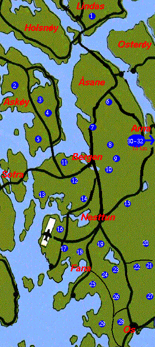
Here are the map-names (maps marked with a star are scanned in):
-
Lindaas
-
Nordre Askoey
-
Storaasen
-
Kolbeinsvarden
-
Brenneklubben
-
Storsaata
-
Munkebotn
-
Floeyen
-
Isdalen(*)
-
Ulriken(*)
-
Lyderhorn
-
Kanadaskogen
-
Alvoen
-
Lovstakken(*)
-
Dyngeland
-
Sandsli
-
Ytrebygda
-
Stendskogen(*)
-
Smoeraasen(*)
-
Myrdalen Totland(*)
-
Frotveit
-
Solbakkefjell(*)
-
Kalandseid(*)
-
Fanafjell Oest(*)
-
Fanafjell Vest
-
Endelausmarka
-
Roedlien
-
Liafjell
-
Vardefjell(*)
-
Fitjavatn Aust(*)
-
Fitjavatn Vest(*)
-
Vardeggi
-
Kyrkjetangen(*)(without description)
-
Varden Skole(*)(without description)
-
Ulriksbanen(*)(without description)
Jan Kocbach: Jan.Kocbach@fi.uib.no